Habitats develop in relation to regional climate, snow-distribution, hydrology, soil chemistry, disturbance and nutrient input. These factors vary across the landscape, creating different habitats. At a circumpolar scale, the arctic vegetation has been mapped based on 16 units (Raynolds et al., 2019; Walker et al., 2005), reflecting large-scale variation in temperature (e.g. among bioclimatic subzones), continentality gradients, and bedrock (Table 1, Fig. 1). At a Svalbard scale, Elvebakk (2005) developed a vegetation map based on ground data with 15 units of vegetation (Fig 2. is a link to external source for this map). In this classification, no units were in common among bioclimatic subzones, underscoring the influence of regional climate. In 2011, a vegetation map for Svalbard was developed based on satellite images (Johansen et al., 2011), which makes the basis for the vegetation map integrated in the thematic Svalbard map provided by the Norwegian Polar Institute.
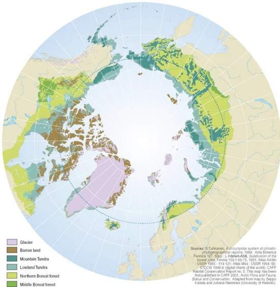
Figure 1. The Circumpolar Arctic Vegetation Map (CAVM) project is an international effort to map the vegetation and associated characteristics of the circumpolar region, The original map from Walker et al. (2005) is the basis for the map shown here made by Grid-Arendal. A raster format of the map was created by Raynolds et al. (2019), and the map units are listed in Table 1.
Follow this link to “The Arctic System” project page to see the vegetation map by Elvebakk (2005) modified by the Norwegian Polar Institute
Code | Unit | Description |
B1 | Cryptogam, herb barren | Dry to wet barren landscapes with very sparse, very low-growing plant cover. Scattered herbs, lichens, mosses and liverworts. Zonal type in dry, continental portions of Arctic Bioclimate Subzones A and B.. |
B2a | Cryptogam, barren complex | Areas of exposed rock and lichens interspersed with lakes and graminoid areas. Subzones C and D on the Canadian Shield. |
B2b | Cryptogam, barren, dwarf-shrub complex | Areas of exposed rock and lichens interspersed with lakes and shrubby areas. Subzones E and D on the Canadian Shield. |
B3 | Non-carbonate mountain complex | Sparse alpine vegetation and rocks on non-carbonate bedrock. The variety and size of plants decrease with elevation and latitude. |
B4 | Carbonate mountain complex | Sparse alpine vegetation and rocks on carbonate bedrock. The variety and size of plants decrease with elevation and latitude. |
G1 | Graminoid, forb, cryptogam tundra | Moist tundra with moderate to complete cover of very low-growing plants. Mostly grasses, rushes, forbs, mosses, lichens and liverworts. Zonal type in maritime portions of Subzones A and B. |
G2 | Graminoid, prostrate dwarf-shrub, forb, moss tundra | Moist to dry tundra, with open to continuous plant cover. Rushes are dominant in Subzone B and sedges in Subzone C, along with prostrate shrubs <5 cm tall. Zonal type in continental portions of Subzone B and C. |
G3 | Non-tussock sedge, dwarf-shrub, moss tundra | Moist tundra dominated by sedges and dwarf shrubs <40 cm tall, with well-developed moss layer. Barren patches due to frost boils and periglacial features are common. Zonal type on nonacidic soils in Subzones D, some C and E. |
G4 | Tussock-sedge, dwarf-shrub, moss tundra | Moist tundra, dominated by tussock cottongrass (Eriophorum vaginatum) and dwarf shrubs <40 cm tall. Mosses are abundant. Zonal type on acidic soils in Subzone E, some D. |
P1 | Prostrate dwarf-shrub, herb, lichen tundra | Dry tundra with patchy vegetation. Prostrate shrubs <5 cm tall (such as Dryas spp. and Salix arctica) are dominant, with graminoids and forbs. Lichens are also common. Zonal type in dry, continental portions of Subzones B and C, and at higher elevations in Subzones D and E. |
P2 | Prostrate/hemi-prostrate dwarf-shrub, lichen tundra | Moist to dry tundra dominated by prostrate and hemiprostrate shrubs <15 cm tall, particularly Cassiope spp. Zonal type in maritime, acidic portions of Subzone C. |
S1 | Erect dwarf-shrub, moss tundra | Tundra dominated by erect dwarf-shrubs, mostly <40 cm tall. Zonal type in continental areas with acidic soils of Subzone D. |
S2 | Low-shrub, moss tundra | Tundra dominated by low shrubs >40 cm tall. Zonal type in warmer, maritime portions of Subzone E, and in areas with deep, moist active layers. |
W1 | Sedge/grass, moss wetland complex | Wetland complexes in the colder areas of the Arctic, dominated by sedges, grasses and mosses. Subzones B and C. |
W2 | Sedge, moss, dwarf-shrub wetland complex | Wetland complexes in the milder areas of the Arctic, dominated by sedges and mosses, but including erect dwarf-shrubs <40 cm tall. Subzone D. |
W3 | Sedge, moss, low-shrub wetland complex | Wetland complexes in the warmer areas of the Arctic, dominated by sedges and shrubs >40 cm tall. Subzone E. |
Plant habitats in Svalbard
Habitats along the ridge - snowbed gradient
Well-defined habitats for plants are forming along the ridge – snowbed gradient. However, the habitat diversity along the gradient is reduced when the regional climate gets colder (Fig. 2). In bioclimatic subzone C, we usually identify four major habitats along this gradient; exposed ridge, mesic plain/slope, moderate snowbed and late snowbed. The species composition varies gradually along the gradient.
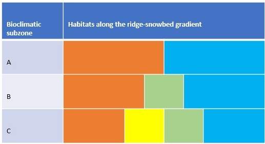
Figure 2. Well-defined habitats for plants are forming along the ridge - snowbed gradient, but the habitat diversity along the gradient is reduced when the regional climate gets colder. In bioclimatic subzone C, we usually identify four major habitats along this gradient; exposed ridge (orange), mesic plain/slope (yellow), moderate snowbed (green) and late snowbed (blue). In the cooler bioclimatic subzone B, the mesic habitat disappears, and the zonal vegetation is found in moderate snowbeds, whereas the coldest areas - the polar desert are rather homogenous, with little differentiation from ridge to slope habitats.
Credit:
Ridge habitats are dominated by drought- and frost-tolerant species that stand wind-abbreviation. In very dry ridges with fine-grained and alkaline substrate, Potentilla pulchella may be the most frequent species, but the most common ridge species in bioclimatic subzone C and B is Dryas octopetala. Carex rupestris is commonly found together with Dryas octopetala on dry ridges with circumneutral to alkaline substrate. Very dry and alkaline ridges will in addition host Carex nardina. However, although Dryas octopetala are common on ridges, it also occurs in areas with some snow protection outside ridges. When Dryas octopetala are dominating together with Salix polaris or Cassiope tetragona, you are no longer on an exposed ridge, but in areas with some snowcover during winter. You may look at some examples of various ridges in our virtual field guides (box med lenker)
The zonal vegetation characterizing bioclimatic subzone C is found in the mesic plain/slope habitat and characterized by Cassiope tetragona (Fig. 3.). In the cooler bioclimatic subzone B, this mesic habitat disappears, and the zonal vegetation is found in moderate snowbeds, with e.g. Luzula nivalis (Elvebakk, 1985). In snowbeds, you find species coping with short growing seasons and thriving in moist habitats, like Ranunculus pygmaeus.
Bioclimatic subzone A, the arctic polar desert, appears to be homogeneous with overall low vascular plant cover (<5 %). The cryptogams are more prominent on acidic substrates than on limestones and shales. Papaver dahlianum is a characteristic plant on exposed ridges and zonal habitats, whereas Phippsia algida is a characteristic species in snowbeds and wet sites.
Wetlands and mires in Svalbard
Habitats related to groundwater table, such as tundra mire, moss tundra, mire, wetland and springs, are mostly dominated by bryophytes. These habitats also vary with regional climate and soil chemistry. Peat-producing mires/fens are limited in the High-Arctic, and only develops within bioclimatic subzone C in Svalbard (Fig. 4.). Tundra mires are only found in cooler areas and do not produce peat (Elvebakk, 1985). Peat might build up due to manuring in colder regions, like under bird-cliffs. This type of vegetation is referred to as moss tundra.
In Svalbard, typical species associated with wetlands and mires are Eriophorum scheuchzeri and Dupontia fisheri, whereas in tundra mires Deschampsia alpina may dominate. Other common species confined to wetter habitats are Alopecurus ovatus, Equisetum arvense, Juncus biglumis, and Cardamine nymanii.
Springs usually covers a small area where oxygenated groundwater wells up from below the earth. The upwelling water’s chemical composition usually reflects the bedrock and sediment deposited by the water. In permafrost environments like Svalbard, the interaction of permafrost and springs can create features called pingos. Pingos are mounds of earth-covered ice that occur due to the pressure of freezing groundwater pushing up a layer of frozen ground. Open system pingos receive liquid water continuously. In Svalbard, the chemical composition of this water varies depending on the source. The marine sediments deposited in e.g. the Advent valley result in water with high salinity. Thus, around pingos you may find vegetation otherwise associated with seashores, such as Stellaria humifusa..
Figure 3. A well-developed Cassiope heath in the warmer parts of bioclimatic subzone C. Ringhorndalen, Svalbard.
Photo: Pernille Bronken Eidesen

Figure 4. Calcareous fens and moss tundra, Kapp Thordsen. Photo: Pernille Bronken Eidesen
Photo: Pernille Bronken Eidesen
VFG Examples:
Alkaline ridges
Shallow mire
Bohemanneset
Mesic plains
Closer to desert and extreme snowbeds
Marine influence
Marin influence may result in the development of salt marsh communities along the coast, lagoons, and river deltas. Well-developed salt marshes are however rare in the Arctic due to the scouring of ice floes in winter and erosion by winter storms if the sea is not fully frozen. Scouring of ice floes continues also during spring and throughout much of the summer. Salt marshes thus develop where there are some shelter, in estuaries and sheltered lagoons behind gravel bars. The species composition of salt marshes varies depending on the degree of salt influence along a gradient. The sedges Carex subspathacea and C. ursina, and the creeping grass Puccinellia phryganodes are common species found in salt marshes, which give the area a distinctive reddish to reddish-brown color. Near or on beach ridges, the beautiful oysterplant (Mertensia maritima) can be found. Another characteristic plant on sandy and gravelly seashores is Honckenya peploides (Fig. 5).
Disturbance affecting all habitats
Although we try to describe defined habitats along e.g. the ridge-snowbed gradient, we rarely find these continuous habitat gradients in nature. What is common, however, is disturbance. Areas with shallow and discontinuous vegetation like in Svalbard are highly prone to erosion. The high level of easily weathered sedimentary rock in Svalbard also creates instability; the valley sides are largely covered by extremely active landslide slopes. The less steep slopes will be affected by solifluction. As permafrost is impermeable to water, the soil in the active layer may become oversaturated with water and slide downslope under the pull of gravity producing lobes along the slope. Freeze-thaw processes in the active layer during summer may create cracks and disturbances increasing solifluction activity. Freeze-thaw processes also create a sorting process of material creating polygon structures and frost boils. This sorting of material creates highly different habitats over very short distances. The finer sediments will hold more water and thus also be more active, where the coarser material will be drier and warmer (Fig. 6).
Nutrients make a difference
Bird cliff meadows are luxuriant communities in dry situations below bird cliffs, and accumulation of peat may develop in manured wetlands, producing moss tundra. Read more about Nutrient inputs.

Figure 5. Honckenya peploides among drift wood in Moskuslaguna, outlet av Advent river.
Photo: Pernille Bronken Eidesen

Photo: Pernille Bronken Eidesen
Figure 6 . Polygon-structures create different soil conditions, micro-topography, moisture and temperature. Thermo-picture of the polygon illustrate how the fine-grained sediments hold more water and thus have a lower temperature.
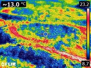
Photo: Pernille Bronken Eidesen
Elvebakk, A. (1985). Higher phytosociological syntaxa on Svalbard and their use in subdivisions of the Arctic. Nordic Journal of Botany, 5(3), 273-284.
Elvebakk, A. (2005). A vegetation map of Svalbard on the scale 1 : 3.5 mill. Phytocoenologia, 35(4), 951-967. https://doi.org/10.1127/0340-269x/2005/0035-0951
Johansen, B. E., Karlsen, S. R., & Tømmervik, H. (2011). Vegetation mapping of Svalbard utilising Landsat TM/ETM+ data. Polar Record, 48(01), 47-63. https://doi.org/10.1017/s0032247411000647
Raynolds, M. K., Walker, D. A., Balser, A., Bay, C., Campbell, M., Cherosov, M. M., Daniëls, F. J. A., Eidesen, P. B., Ermokhina, K. A., Frost, G. V., Jedrzejek, B., Jorgenson, M. T., Kennedy, B. E., Kholod, S. S., Lavrinenko, I. A., Lavrinenko, O. V., Magnússon, B., Matveyeva, N. V., Metúsalemsson, S., . . . Troeva, E. (2019). A raster version of the Circumpolar Arctic Vegetation Map (CAVM). Remote Sensing of Environment, 232, <xocs:firstpage xmlns:xocs=””/>. https://doi.org/10.1016/j.rse.2019.111297
Walker, D. A., Raynolds, M. K., Daniels, F. J. A., Einarsson, E., Elvebakk, A., Gould, W. A., Katenin, A. E., Kholod, S. S., Markon, C. J., Melnikov, E. S., Moskalenko, N. G., Talbot, S. S., & Yurtsev, B. A. (2005). The Circumpolar Arctic vegetation map. Journal of Vegetation Science, 16(3), 267-282. <Go to ISI>://000231506600002